Ywahoo Creek is the source for Ywahoo Falls near Whitley City, Kentucky. A trail goes to Ywahoo Creek where a ford can be made by foot travel. A huge rock shelter is present at the Falls area. The scenic Ywahoo Falls area is in the Big South Fork National River and Recreation area. The narrow road that must be used to access the Falls Area begins at a local fueling station called Becky’s. Adjacent to the Big South Fork property is the Daniel Boone National Forest. The Ywahoo Falls area is a dramatically scenic natural area.
Showing posts with label McCreary County. Show all posts
Showing posts with label McCreary County. Show all posts
Thursday, July 1, 2021

Wednesday, May 6, 2020
Kentucky's Favorite Places
 |
| Cumberland River, High Water, Kentucky |
The stone bridge constructed by the CCC at Kentucky's beautiful Pine Mountain State Park. The high explosives storage structure and the cabins constructed by the CCC at Cumberland Falls State Park. The stone fenced overlook constructed by the CCC at General Butler state park. The woodland steps constructed by the CCC at John James Audubon state park. These are places to lift our spirits. The CCC made these bridges and other things out of a faith that our country could come out of hard times. It can happen again.
Saturday, January 10, 2015
What I saw - Big South Fork of the Cumberland River
 |
| Trail along the shore of the Big South Fork of the Cumberland River |
 |
| The Big South Fork of the Cumberland River - Devils Jump passage |
"There is a love of wild Nature in everybody, an ancient mother-love ever showing itself whether recognized or no, and however covered by cares and duties."
John Muir
Saturday, December 6, 2014
Southeast Kentucky
There is more to take in about South East Kentucky than delicious fried chicken. Yes London does have a big chicken dinner in September built around the last weekend in September. The festival boasts the biggest skillet in the country. Late Fall and Winter is a good time to come to the Valley.
It is a time to move about without the worry of humid air or ticks or mosquitoes. The beauty of the stream banks will come into you. The music of the winds will come to your ears. You will take back the sights and sounds and remember them. You will appreciate them.
It is a time to move about without the worry of humid air or ticks or mosquitoes. The beauty of the stream banks will come into you. The music of the winds will come to your ears. You will take back the sights and sounds and remember them. You will appreciate them.
 |
| The Cumberland River - Southeast Kentucky |
Wednesday, December 3, 2014
Protect Fish, Wildlife and Plants; Kentucky's NRRA
 |
| Rock Bluffs - Big South Fork NRRA |
 |
| Huge Cliffs with walking space in between - Big South Fork NRRA |
 |
| Trail near Blue Heron - Big South Fork NRRA |
A wide variety of habitats and associated wildlife are found at the Daniel Boone National Forest and the Big South Fork NRRA. This area of impressive cliffs and rocks is in the Blue Heron area of the Big South Fork NRRA. Writing or photography can only go so far; one has to be there to experience it.
Wednesday, October 29, 2014
Heritage
 |
| Big South Fork Scenic Railway - Kentucky Tennessee Railroad tracks |
 |
| Big South Fork Scenic Railway - Stearns Kentucky |
The town of Stearns, Kentucky is the depot for the rail trips into the Big South Fork NRRA. The Big South Fork NRRA has many rock shelters. The rock shelters provide habitats for a variety of plants.
"All those hours exploring the great outdoors made me more resilient and confident."
David Suzuki
Come to the forest. Find a health way.
Tuesday, October 28, 2014
The Big South Fork of the Cumberland River
 |
| Big South Fork NRRA - Kentucky and Tennessee |
The Big South Fork NRRA is located in McCreary County, Kentucky and Fentress, Pickett, and Scott Counties in Tennessee. The Great Smoky Mountains National Park is located in Blount, Sevier and Cocke Counties in Tennessee and Swain and Haywood Counties in North Carolina. A study of the plants living in the Big South Fork NRRA found a greater variety of plants living in the Big South Fork NRRA in comparison to the Great Smoky Mountains National Park. The rock shelters and the temperatures of the Big South Fork NRRA may provide a greater variety of habitats than the Great Smoky Mountains National Park. If the Star Trek transporter were available to me I would probably choose the the Great Smoky Mountains. If I must drive myself I would be happy to go to the Big South Fork. The thought of leaving today buoys my heart. I have seen Twin Arches in the Big South Fork NRRA; the scenery there makes Big South Fork NRRA trip worthy. Both the Great Smoky Mountains National Park and the Big South Fork NRRA have their beauty. And two parks complement each other; one straddles the Tennessee border with Kentucky and one straddles the Tennessee border with North Carolina. The story of Big South Fork NRRA and the surrounding Daniel Boone National Forest is a story of redemption. These were once ugly places and they have been transformed. Now they are appealing places.
Monday, October 27, 2014
The Big South Fork NRRA
 |
| Textile in McCreary County Museum - Conveyor across river is shown |
Formed by the confluence of the New River and the Clear Fork, the Big South Fork of the Cumberland River is a major tributary of the Cumberland River. The mighty Cumberland River is itself a tributary of the Ohio River. Because the Big South Fork gathers runoff from an extensive rainy area lying more than 1,000 feet above sea level, it has a steep gradient and plenty of flow. Long stretches of the river are sufficiently constricted, steep, and swift running to offer whitewater canoeing and kayaking.
This part of America has a deep history. The first people in the Big South Fork area were Paleoindians whose culture spanned the era from about 13,000 B.C. to 7,900 B.C. Beginning about 12,000 years ago these prehistoric First Peoples began living in rockshelters and supported themselves by hunting and gathering in the forests of the upper Cumberland Plateau. They eventually did some farming too, and created small, round indentations in the sandstone floors of the rockshelters. These are “hominy holes,” so named because the First Peoples ground maize and other grains in them.
Hominy holes are not the only evidence left behind by pre-European people of the Big South Fork country. American Indians used this land long after the First Peoples, albeit in a much more transient way. Cherokees and other Indians established temporary hunting camps in the rockshelters, leaving behind pottery shards, stone projectile points, and other artifacts. Thanks to its rich heritage, Big South Fork NRRA is home to more archaeological sites than any other park in the Southeast Region.
Europeans began moving into the area in the late 1700s. The first frontiersmen, poachers called longhunters, were followed by settlers who established homes along the creeks at the top of the gorge. With place names such as Parch(ed) Corn Creek, Difficulty Creek, Troublesome Creek, Lonesome Creek, and No Business Creek, it’s easy to imagine how tough life must have been for these pioneers. Scraping out a living from the poor, rocky soil offered a tenuous living at best. As late as the Civil War era, cartographers were still labeling this area “The Wilderness.”
In the early- to mid 1900s, coal and timber companies began flocking to the Big South Fork region, temporarily strengthening the settlers' lives by bringing sought after jobs and a reasonable semblance of a cash economy.
Mine 18 operated from 1938 until 1962, supplying coal for local railroads and other purposes. The town of Blue Heron, which emerged in association with the mine, was also abandoned in 1962. The Stearns Company eventually owned or controlled 128,000 acres of land in the Big South Fork area, extracting coal, sand, timber, and even oil.
Most residents of the region were held strongly in the grip of poverty. Farming yielded little more than subsistence, and the area’s two major industries, logging and mining, were both capitalized and controlled by outsiders who cared little about the people or the landscape.
As the coal mines gradually closed and the regional economy deteriorated during the 1960s, the residents of the region turned to their elected officials for help. Howard H. Baker, Junior, is fondly remembered for the efforts he made on behalf of Big South Fork area people, which included going door-to-door at one point to help the Scott County government raise money needed to purchase the local telephone company.
In 1966, the people of Scott County and the surrounding area elected Baker to the United States Senate. His father had served in the Senate from 1951 to 1964. Senator Baker worked tirelessly to get better roads, schools, health care facilities, and other needed infrastructure for his east Tennessee constituents. And he understood full well that what the people of the region needed most of all was more and better jobs.
Senator Baker first entertained the idea of building a dam on the Big South Fork River. “In those days, the way to progress was to build a dam,” he recollected in a TV interview. If constructed, the new dam might have emulated the success of the TVA dams and brought jobs, electricity, tourism, and other economic benefits, but at a the expense of some of the best scenery and recreational resources in this part of America. The natural features would be inundated by the manmade lake.
Senator Baker and Senator John Sherman Cooper (R-KY) recognized that the Big South Fork, with its gorges, homesteads, rockshelters, and arches, was worth more preserved than flooded. The two Senators sponsored and shepherded through Congress the legislation that created Big South Fork National River and Recreation Area, which was signed into law on March 7, 1974, by President Nixon. The new law directed the Corps of Engineers to acquire land for the park and build the facilities before turning the park over to the National Park Service for administration. (1)
The Corps quickly drew up plans for what some were calling 'The Yellowstone of the East” and started buying land. By 1986, National Park Service personnel were staffing a small visitor center on the East Rim, and the Bandy Creek Campground had opened its gates for the first time, welcoming visitors with hot showers, a camp store, stables, and craft store.
In 1989, the Blue Heron Mining Community opened with much fanfare. Mine 18 of Stearns Coal and Lumber Company fame had been reborn as semi-restored ghost town. Thirteen “ghost structures” consisting only of framing, the bare bones of buildings, stood at the mining community. These structures recalled homes, the company store, churches, machine shops, and more. Supplementing these ghost structures were oral histories that visitors could listen to while viewing artifacts, photographs, and other items from Mine 18's heyday.
The original coal tipple, a central facility for loading coal to be transported, was restored for exhibit. A mine opening was also carefully preserved and stabilized so that visitors could enter it.
The establishment of the Big South Fork Scenic Railway was also a milestone in the park's early history. Run by the McCreary County Heritage Foundation, the train departs the historic Stearns Depot atop the river gorge. Today travelers can take a train trip from Stearns, KY to Mine 18 on the track of the Kentucky and Tennessee railroad. The trip is downhill to reach the level of Mine 18. Thinking of the weights of the hopper cars the work to bring the coal up the Stearns must have been a feat in the days of early railroad design. The journey recalls the days of the Kentucky and Tennessee railroad which also provided passenger service in its day.
By 1991, most of the land had been bought for the park and the majority of the facilities were in place. The Corps, having realized a much smaller version of the grand park than they originally sought to create, turned everything over to the National Park Service. The 1991 transfer coincided with the dedication of the new Headquarters and the 75th Anniversary of the National Park Service.
By 2005 the National Park Service completed the park's first General Management Plan, which implements changes and positions the park for a new era.
Visitors to Big South Fork find a wide range of activities. Camping is very popular. While the camp and craft stores at Bandy Creek are no longer in operation, the park still boasts one of the cleanest and most peaceful RV-friendly campgrounds in the park system, complete with stables, a public swimming pool, hot showers, volleyball courts, and playgrounds. The Park Service has met the needs of tent campers as well, with a special tents-only section of the campground situated atop a small wooded hill.
Families will delight in the park’s hiking trails, which wind past homesteads, bluffs, arches, overlooks, and the river. Horseback riders take to the more than 200 miles of horse trails in the area, and canoeists flock to the Big South Fork. Mountain bikers are welcome to use Big South Fork’s three bikes-only trails as well as most horse paths. Rock climbing and rappelling are also favorite activities. Each September, the park hosts the“Haunting in the Hills” Storytelling Festival, which attracts several thousand visitors and showcases the area's mountain heritage, music, crafts, and the talents of local storytellers.
All of the land that was under the Stearns control is now in the Big South Fork NRRA or the Daniel Boone National Forest or private land.
(1) http://www.nationalparkstraveler.com/2008/09/park-history-big-south-fork-national-river-and-recreation-area accessed 23 October 2014.
(1) http://www.nationalparkstraveler.com/2008/09/park-history-big-south-fork-national-river-and-recreation-area accessed 23 October 2014.
Thursday, October 23, 2014
Kentucky Legacy
 |
| The Blue Heron Coal Camp Scale Model at Big South Fork NRAA |
The Stearns Coal and Lumber Company began operation in 1902 on land purchased in Kentucky and Tennessee. At the same time that the lumber industry was being established coal mining operations began. The first Stearns Company coal mine opened in 1902 and the first coal shipments were made in 1903. In 1918 the lumber industry was dwindling in Mason County, Michigan and Mr. Stearns closed the lumber company.
 |
| Coal Conveyor Over the Big South Fork Modified for Foot Travel (Compare with photo of the conveyor during mine operation) |
 |
| Coal Conveyor for Bringing Coal to the Tipple at Mine 18 (Blue Heron Mine) |
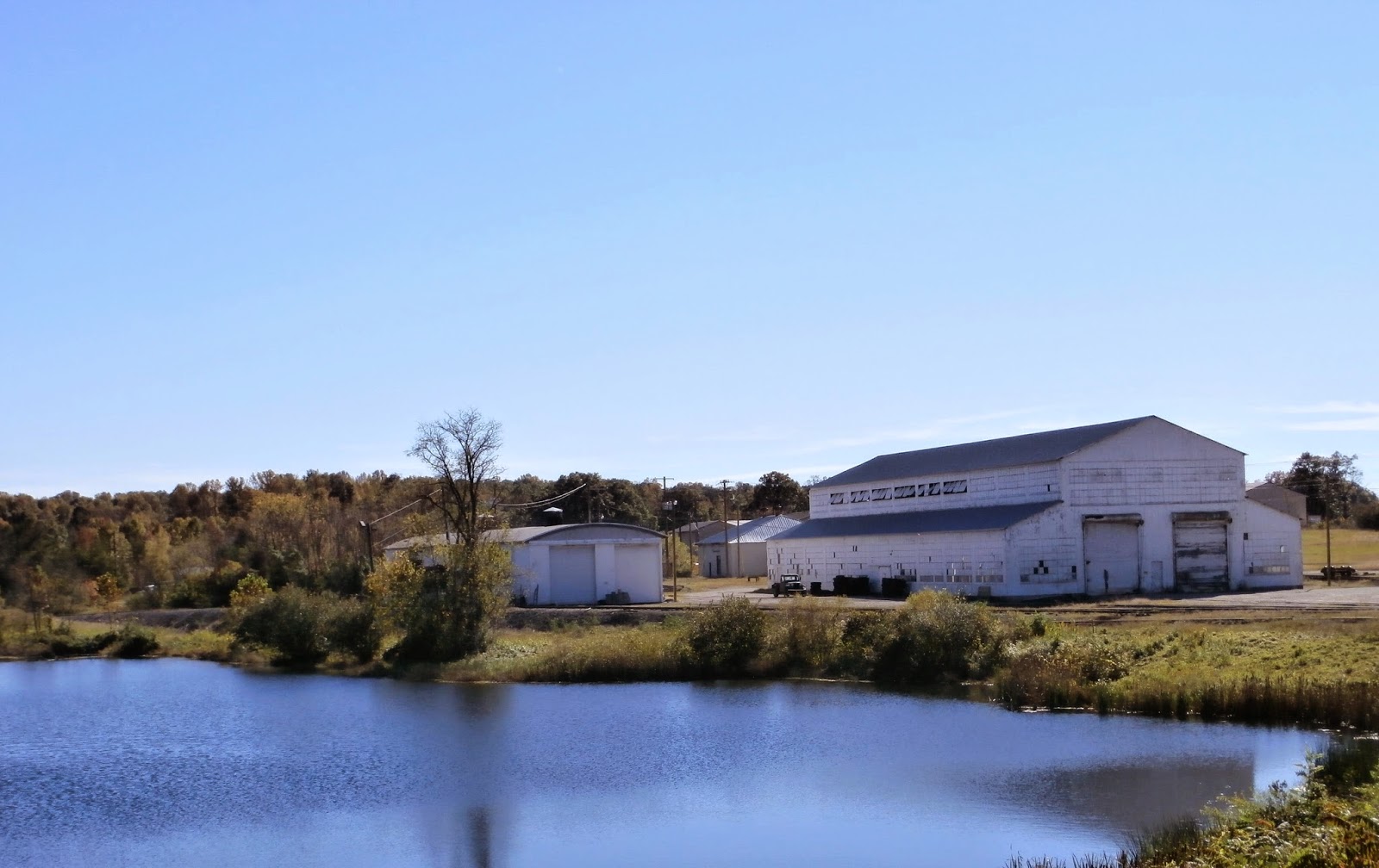 |
| Kentucky and Tennessee Railroad Pond and Locomotive Shop, Stearns, KY |
The company continued under Justus Sterns’ offspring. Robert L. Stearns, Sr., Robert L. Stearns, Jr. and Robert Eiledy Gable all ran the company over the time of the Stearns Company’s presence in Kentucky and Tennessee. In the 1902 the Stearns company began building a railroad to connect the mines to the Southern Railroad. The Stearns Railroad became the Kentucky and Tennessee railroad.
It reached mine No. 1 at Barthell, mine No. 4 at Worley, mine No. 11 at Yamacraw, Cooperative Coal Company at Cooperative,; mine No. 15 at White Oak, and mine "A" at Fidelity. Cooperative was a new mine which was organized to give Stearns employees the privilege of buying its stock and sharing its earnings. The Kentucky and Tennessee railroad also ran to the Paint Cliff Mine Company, , the St. Mihiel Coal Company at Oz, and the Camargo Coal Company at Camargo. The president of the Paint Cliff mine company was Kenneth Meguire of Louisville. Later the Railroad reached Mine 18 at Blue Heron.
It reached mine No. 1 at Barthell, mine No. 4 at Worley, mine No. 11 at Yamacraw, Cooperative Coal Company at Cooperative,; mine No. 15 at White Oak, and mine "A" at Fidelity. Cooperative was a new mine which was organized to give Stearns employees the privilege of buying its stock and sharing its earnings. The Kentucky and Tennessee railroad also ran to the Paint Cliff Mine Company, , the St. Mihiel Coal Company at Oz, and the Camargo Coal Company at Camargo. The president of the Paint Cliff mine company was Kenneth Meguire of Louisville. Later the Railroad reached Mine 18 at Blue Heron.
The Big South Fork NRAA is one of
only two national parks designated “national river and recreation area” (the
other being the Mississippi National River and Recreation Area in the
Minneapolis-St. Paul vicinity). The Big South Fork is a place once broken with rapacious
timber cutting but now healing under protection of the National Park Service.
Located high atop the Cumberland Plateau in McCreary County
Kentucky and Pickett and Scott Counties in Tennessee Big South Fork has more
than 125,000 acres of land. Big South Fork is a geological and historical resource. The land has deep gorges carved by erosion,
historic homesteads of a bygone era, and scenic rockshelters and sandstone
arches.
An ancient inland sea covered this part of America some 320
million years ago. The sandbars, deltas, beaches, and dunes were compressed and
cemented over millions of years, becoming fine-grained sandstone. Other
sedimentary rocks were formed in some places as well, including siltstone,
shale, and coal.
The sedimentary rock strata of the Cumberland Plateau are
layered. Atop these strata sits a layer
of rock called the Rockcastle Conglomerate. This rock consists of
cemented-together coarse sand and small pebbles from ancient braided
streambeds. The Rockcastle Conglomerate layer functions as a cap rock because
it is very erosion-resistant.
As the land tilted upward rose, replacing the sea with
highlands, rivers became a powerful force for cutting into the landscape. Where
the running water breached the erosion resistant conglomerate cap rock, it was
able to carve deeply into the softer sedimentary rock below. This vigorous cutting
created gorges, cliffs, bluffs, and arches. Over time, these processes gave
birth to the Big South Fork landscape of today.
Wednesday, October 22, 2014
What I Saw - Under Hemlock Boughs
 |
| Kentucky Artisan Center - Art on Display |
 |
| Green Eastern Hemlock - Blue Heron Mine - Big South Fork |
 |
| Blue Heron Mine - Big South Fork, NRRA |
The Kentucky Artisan Center at Berea, Kentucky offers travelers opportunities to purchase framed art and various Kentucky made items. The Center is constructed of stone and has the appearance of the layered stone of the region’s riverbanks. Outdoor banners suggest that visitors continue to laugh and learn in their life.
The First Christian Church in Corbin, Kentucky is a
Disciples of Christ church. It is
centrally located on Kentucky Avenue and has been at that location since its
construction in 1925. The building is equipped
with an elevator for those who would have difficulty with stairs or those with
limited mobility
Ludington is a harbor town located on Lake Michigan at the
mouth of the Pere Marquette River in Michigan.
Justus S. Stearns moved to Ludington, Michigan from New York and Ohio in
1876. He was in the business of cutting
trees for lumber. He sought the office
of governor of Michigan in 1898 but was defeated. In 1899 he had agents looking in Kentucky and
Tennessee for new tracts to make use of for timbering operations. The Stearns
Coal and Lumber Company began operation in 1902 on land purchased in Kentucky
and Tennessee. At the same time that the lumber industry was being established coal
mining operations began. The first Stearns Company coal mine opened in 1902 and
the first coal shipments were made in 1903. In 1918 the lumber industry was
dwindling in Mason County, Michigan and he closed the lumber company.
The company continued under Justus Sterns’ offspring. Robert
L. Stearns, Sr., Robert L. Stearns, Jr. and Robert Eiledy Gable all ran the
company over the time of the Stearns Company’s presence in Kentucky
and Tennessee. In the 1902 the Stearns company began building a railroad to connect the mines to the Southern Railroad. The
Stearns Railroad became the Kentucky and Tennessee railroad.
It reached mine No. 1 at Barthell, mine No. 4 at Worley, mine No. 11 at Yamacraw, Cooperative Coal Company at Cooperative,; mine No. 15 at White Oak, and mine "A" at Fidelity. Cooperative was a new mine which was organized to give Stearns employees the privilege of buying its stock and sharing its earnings. The Kentucky and Tennessee also ran to the Paint Cliff Mine Company, whose president was Kenneth Meguire of Louisville, the St. Mihiel Coal Company at Oz, and the Camargo Coal Company at Camargo. Later the Railroad reached Mine 18 at Blue Heron.
It reached mine No. 1 at Barthell, mine No. 4 at Worley, mine No. 11 at Yamacraw, Cooperative Coal Company at Cooperative,; mine No. 15 at White Oak, and mine "A" at Fidelity. Cooperative was a new mine which was organized to give Stearns employees the privilege of buying its stock and sharing its earnings. The Kentucky and Tennessee also ran to the Paint Cliff Mine Company, whose president was Kenneth Meguire of Louisville, the St. Mihiel Coal Company at Oz, and the Camargo Coal Company at Camargo. Later the Railroad reached Mine 18 at Blue Heron.
Today travelers can take a train trip from Stearns, KY to
Mine 18 on the track of the Kentucky and Tennessee railroad.
Friday, June 13, 2014

Subscribe to:
Posts (Atom)